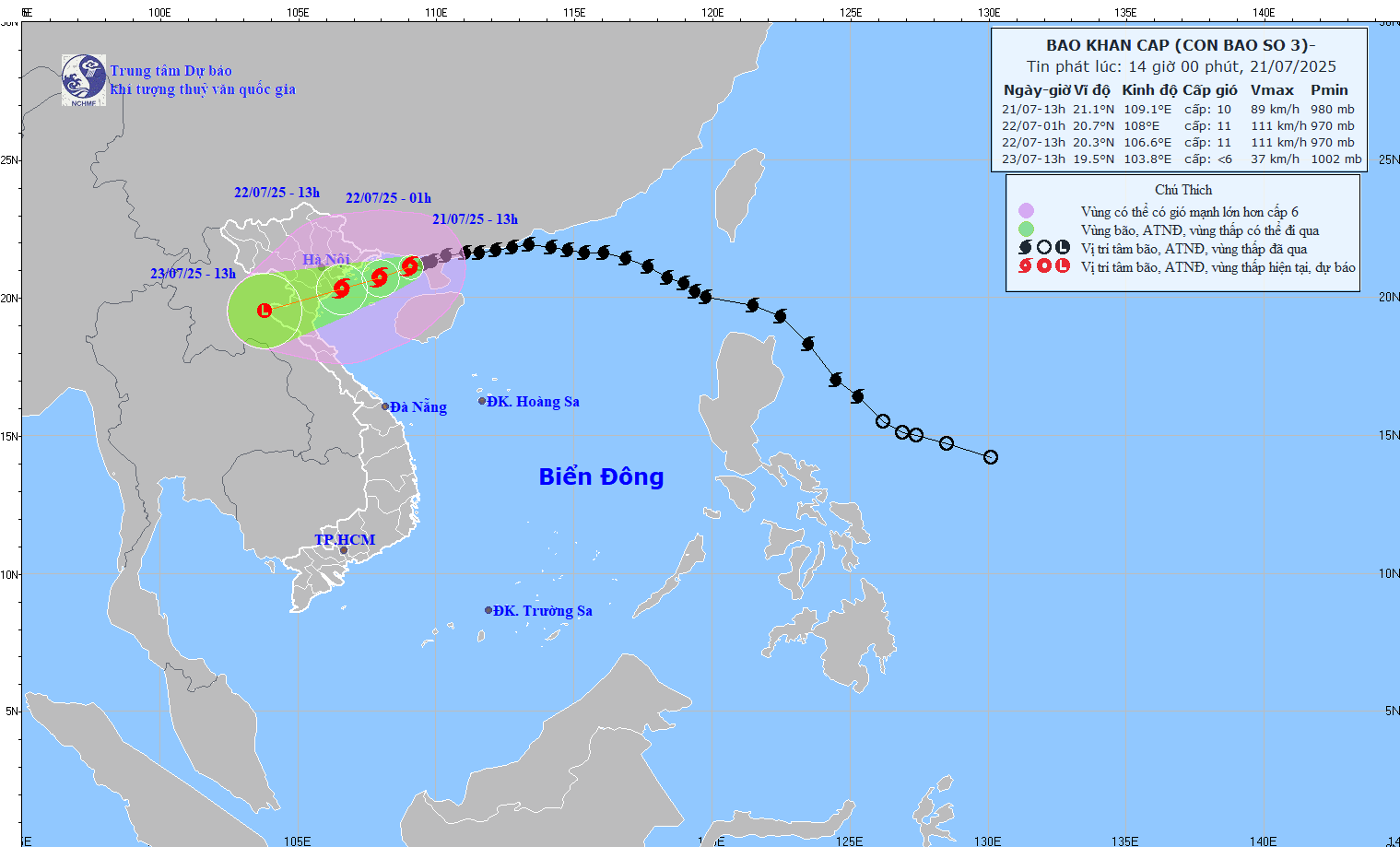
As of the afternoon of July 21, Typhoon Wipha (Storm No. 3) has intensified to Category 10, with gusts reaching Category 12. The storm’s center was located approximately 120km from Quang Ninh, 260km from Hai Phong, 280km from Hung Yen, and 310km from Ninh Binh. The Bach Long Vi special zone reported gusts at Category 9.
According to the National Center for Hydro-Meteorological Forecasting (NCHMF), the storm has caused strong winds in coastal areas: Category 8 with gusts at Category 9 in Bach Long Vi, and Category 6 with gusts at Category 7 in Co To.
By 1 PM on July 21, the storm was located east-northeast of Quang Ninh, moving west-southwest at 10-15km/h, with maximum sustained winds of 75–102km/h (Category 9-10), gusting to Category 12.
Storm intensifies, projected to strengthen further
Forecasts indicate that by 1 AM on July 22, Wipha will maintain its direction and speed, possibly intensifying further. The center is expected to be over the northern part of the Gulf of Tonkin, with wind strength reaching Category 10-11 and gusts up to Category 14.
The danger zone at sea includes areas north of 18.5°N latitude and between 106°E and 112°E longitude. Affected regions encompass the northwestern East Sea, the Gulf of Tonkin, and coastal waters from Quang Ninh to Ninh Binh. Disaster risk level is rated at Level 3.
By 1 PM the same day, the storm is projected to move west-southwest toward waters between Hai Phong and Thanh Hoa, maintaining intensity at Category 10-11, gusting to Category 14. The danger zone will extend further west to include land areas from Quang Ninh to Nghe An. The disaster risk level remains at Level 3.
By July 23 at 1 PM, Wipha is forecast to weaken into a tropical depression over the upland regions of northern Laos, with wind speeds dropping below Category 6. Despite weakening, strong winds and heavy rain will continue to affect areas from Quang Ninh to Nghe An.
Expected impacts
In the northwest of the northern South China Sea, wind speeds will reach Category 7-8, gusting to Category 10, with waves 3–5m high and very rough seas. In the northern Gulf of Tonkin, including islands such as Bach Long Vi, Co To, Van Don, Cat Hai, and Hon Dau, winds are forecast to reach Category 6-7, strengthening to Category 10-11 near the storm center, with gusts up to Category 14. Wave heights in these zones may range from 4–6m.
In the southern Gulf of Tonkin (including Hon Ngu Island), winds will strengthen to Category 6-7, increasing to Category 8-9 near the center, gusting to Category 11, with 2–4m waves and very rough seas.
Storm surge and coastal flooding risk
Coastal areas from Hung Yen to Quang Ninh may experience storm surges of 0.5–1m. Water levels are expected to peak at 2.4–2.6m in Ba Lat (Hung Yen), 3.9–4.3m in Hon Dau (Hai Phong), 4.6–5m in Cua Ong (Quang Ninh), and 3.6–4m in Tra Co (Quang Ninh). Coastal and estuarine regions are at high risk of flooding on July 22.
Warning: Weather conditions at sea and along coastal land during the storm are extremely dangerous. All activities involving transport or structures in high-risk zones - such as tourist boats, passenger and cargo ships, floating farms, aquaculture, sea dikes, embankments, and coastal roads - are unsafe. Vessels face high risk of capsizing or damage due to strong winds, thunderstorms, rough seas, and storm surges.
On land
From the evening of July 21, coastal provinces from Quang Ninh to Nghe An will experience increasingly strong winds at Category 7-9, with areas near the storm center reaching Category 10-11 and gusts up to Category 14. Inland regions of Hai Phong, Hung Yen, Ninh Binh, and Thanh Hoa will see Category 6 winds, gusting to Category 7-8. Winds at Category 10-11 could uproot trees, topple power poles, tear off roofs, and cause significant property damage.
Heavy rainfall
Between July 21–23, northeastern provinces, the Red River Delta, Thanh Hoa, and Nghe An are expected to receive heavy to very heavy rain, with widespread totals of 200–350mm, and localized areas exceeding 600mm. Other parts of northern Vietnam and Ha Tinh may see 100–200mm of rain, with isolated areas exceeding 300mm.
Warning: Rainfall rates may exceed 150mm in three hours. Intense rainfall over a short period increases the risk of flash floods, landslides in mountainous areas, and urban flooding in low-lying zones.
Bao Anh