The system is expected to move slowly over the next three hours. However, the storm’s circulation continues to bring heavy rainfall to Thanh Hoa and Nghe An.
On the afternoon of July 22, the National Center for Hydro-Meteorological Forecasting reported that Storm Wipha had shown little movement over the previous three hours. At 4:00 PM, Hon Dau (Hai Phong) recorded wind speeds of level 8 with gusts at level 10. Other recorded wind conditions included Uong Bi (Quang Ninh) at level 7, gusting to level 8; Van Ly (Ninh Binh) at level 8, gusting to level 10; and Ba Lat (Hung Yen) at level 7, gusting to level 9.
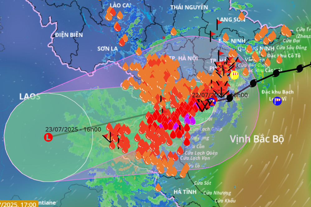
By 4:00 PM, the storm had not yet dissipated. At that time, its center was located over land in Ninh Binh and Thanh Hoa. Maximum sustained winds near the center reached level 8 (62–74 km/h), with gusts up to level 10, moving westward at 10–15 km/h.
Over the next 24 hours, the storm will continue on a west-southwest trajectory at 10–15 km/h, weakening into a tropical depression and then into a low-pressure zone over the Upper Laos region.
Due to the storm’s influence, during the late afternoon and evening of July 22, the Gulf of Tonkin - including Bach Long Vi, Co To, Van Don, Cat Hai, Hon Dau, and Hon Ngu islands - experienced strong winds at level 6–7, level 8 near the storm’s center, and gusts up to level 10. Waves reached heights of 2–4 meters, causing very rough seas.
Meteorological authorities continue to issue severe weather warnings for marine and coastal areas impacted by the storm, deeming conditions extremely dangerous. All vessels and infrastructure in these regions - including passenger boats, cargo ships, fish farms, aquaculture cages, dikes, embankments, and coastal roads - face a high risk of capsizing, damage, or flooding due to strong winds, thunderstorms, and large waves.
Heavy rain continues in many regions
Later in the evening, at 7:00 PM, the storm officially weakened into a tropical depression over Ninh Binh and Thanh Hoa provinces, and is forecast to move slowly over the next three hours.
By 7:00 AM on July 23, the tropical depression is expected to continue moving west-southwest at about 10 km/h and gradually weaken into a low-pressure area over Upper Laos.
On land, coastal regions from Quang Ninh to Nghe An are still experiencing strong winds at level 6–7, with gusts at level 8–9. Inland areas such as Hung Yen, Ninh Binh, and Thanh Hoa are seeing gusts at levels 6–7.
Due to the post-storm circulation, from the evening of July 22 through the morning of July 23, heavy to very heavy rainfall is expected in Thanh Hoa, Nghe An, southern Phu Tho, and Son La, with totals ranging from 40–100 mm, and isolated areas receiving over 200 mm. Warnings have been issued for high-intensity rainfall (>150 mm in 3 hours).
From the evening of July 22 to the afternoon of July 23, other areas in the North and Ha Tinh may experience light to moderate rain, with some locations receiving 20–40 mm and isolated areas exceeding 100 mm.
Scattered showers and thunderstorms are also expected tonight across the Central Highlands and southern Vietnam, with localized heavy rainfall reaching 10–30 mm, and in some places over 70 mm.
Notably, from July 24–25, the northern region, Thanh Hoa, and Nghe An may continue to experience moderate to heavy rain and thunderstorms, with localized very heavy rainfall.
In addition, meteorologists warn that in the six hours following 4:30 PM on July 22, there is a risk of flash floods, landslides, and ground subsidence along slopes and small streams in the provinces of Son La, Phu Tho, Lao Cai, Thanh Hoa, Nghe An, and Ha Tinh.
As of 3:45 PM on July 22, coastal and river mouth monitoring stations recorded sea level rises of 0.5–0.8 meters. At Ba Lat hydrological station (Hung Yen), water rose by 0.8 meters, with a peak level at 2:50 PM of 2.97 meters - surpassing the historic 2017 record by 0.26 meters. At Dong Quy station (Hung Yen), water levels rose 0.6 meters to 2.44 meters and are continuing to rise.
Storm No. 3 has also caused sea level surges, compounded by strong southeast winds along the Hung Yen coastline that are pushing seawater inland.
Bao Anh